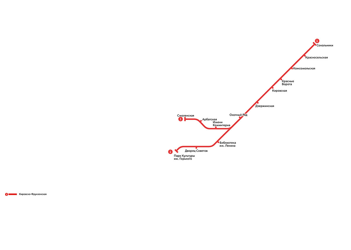
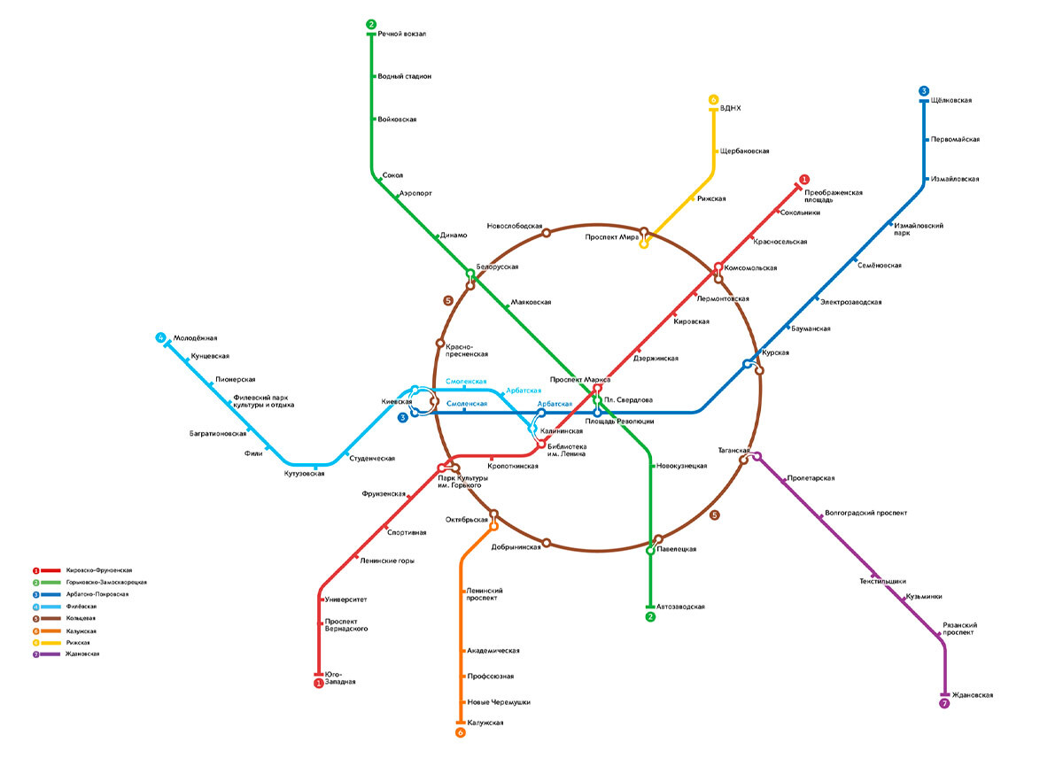
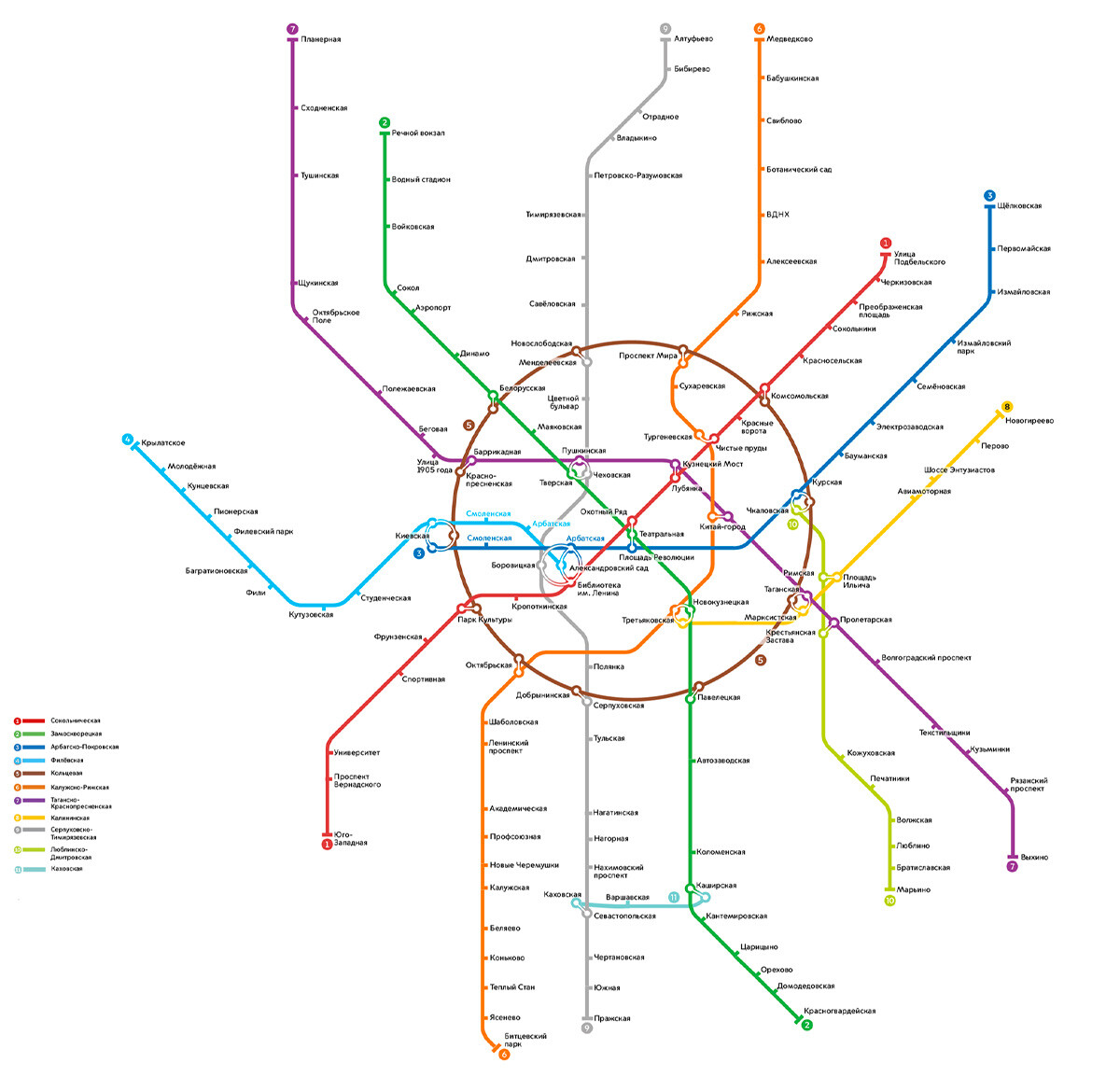
It's difficult to imagine a time when the map of the Moscow Metro did not look like a tangled behemoth and was merely a single line. The first Metro line opened in 1935 with 13 stations. Called the Sokolnicheskaya Line, it ran from Sokolniki Park to Okhotny Ryad in the very center of Moscow; then branching off to Park Kultury and Smolenskaya stations (the latter is on a different line today).
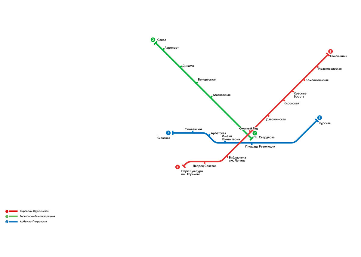
Within three years of the first line's opening, two more had been built. In 1937, the spur from Smolenskaya station was made into a separate blue-colored line (Arbatsko-Pokrovskaya) and extended to Kievskaya station; while at its other end it reached Kurskaya station, thus creating a metro link between Kursky and Kievsky railway terminals.
In 1938, the green-colored line (Gorkovsko-Zamoskvoretskaya) was opened from Ploshchad Sverdlova station (today: Teatralnaya) to Sokol station on the Leningradsky Highway.
Construction of the Moscow Metro didn’t even take a break during World War II. In fact, certain stations served as bomb shelters. There was a contingency plan that in the event of a successful German attack on the capital, the authorities contemplated destroying the Metro, but thankfully this did not happen. There was only one day in the Moscow Metro’s history – on October 16, 1941 – when it did not open its doors to passengers, (nowadays it's known as the "day of panic").
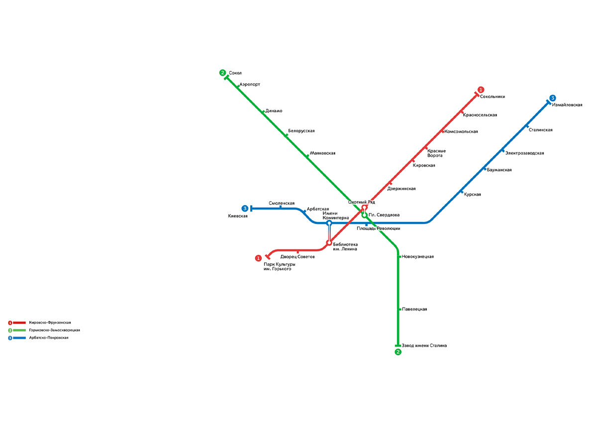
By the end of the war seven stations had been added to the Metro network. The blue line was extended to Izmaylovskaya station, the location of a military airfield, and the green-colored line to the station “Zavod imeni Stalina” (today: Avtozavodskaya).
In addition, several new passenger interchanges between different lines were built.
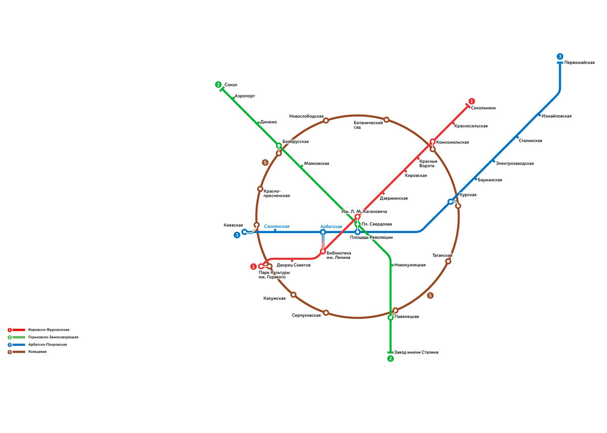
The first semi-circle of the Koltsevaya (Circle) Line was built in 1951, linking Kurskaya station and Park Kultury in the south. Subsequently, the circle was closed when the northern section was also completed. This allowed for convenient travel between railway terminals located on different lines. The Koltsevaya Line stations with interchanges for railway terminals were: Kievskaya, Belorusskaya, Komsomolskaya (serving three rail terminals: Leningradsky, Yaroslavsky and Kazansky), Kurskaya and Paveletskaya stations.
By the late 1950s some of the older existing lines had been extended — the Sokolnicheskaya Line was lengthened as far as Leninskiye Gory and Universitet stations, the area of the city where in 1953 one of the Stalinist skyscrapers – the Moscow University building – was completed and opened.
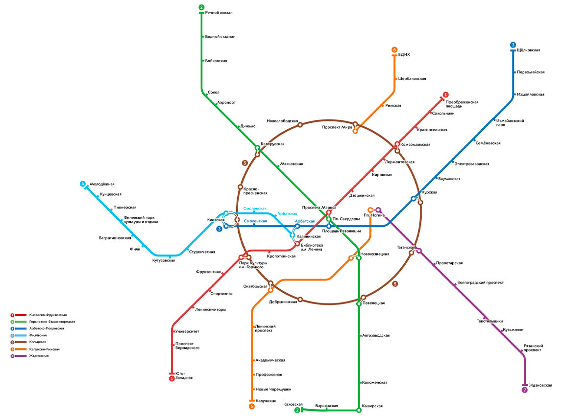
Starting in the end of the 1950s, radial lines were added to the Koltsevaya Line, which is why today, when two interchange stations are identically named, people have the habit of adding "koltsevaya" or "radialnaya" to make it clear whether they mean the circle or radial line station.
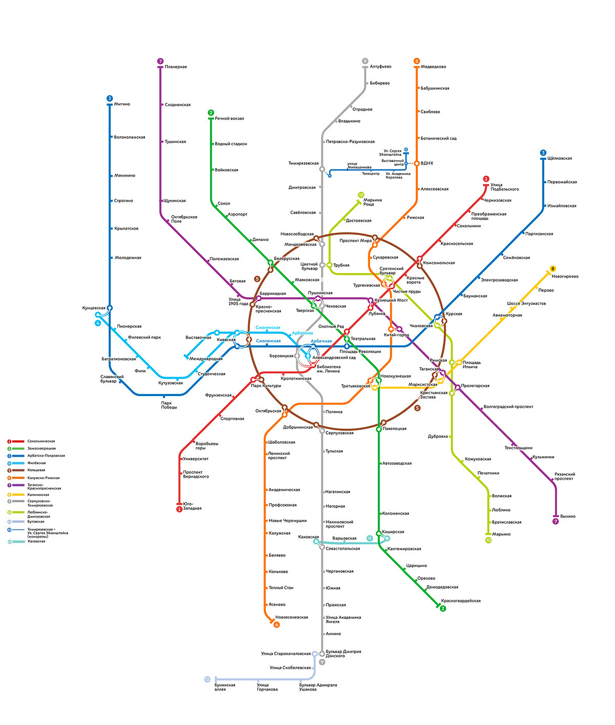
Eventually, the principle of radial lines branching off from the Koltsevaya Line was somewhat breached. By 1971, the orange line had been brought into the city center as far as Ploshchad Nogina station (today Kitay-Gorod station). At the same time, the yellow radial line from VDNKh was changed to orange as part of a plan to combine the two into a single line.
Additionally, the new purple line was extended to Ploshchad Nogina from the suburbs – a number of suburban trains served Zhdanovskaya station, making the lives of people commuting from the Moscow Region much easier.
In 1969, there was the opening of two stations as an offshoot of the green Gorkovsko-Zamoskvoretskaya Line – from Kolomenskaya to Kakhovskaya stations. The line already had independent status from 1995 onwards, and now it's part of the Bolshaya Koltsevaya Line completed in 2023.
By 1972, two sections of the orange Kaluzhsko-Rizhskaya Line were linked together according to a modernization plan, and it was significantly extended northwards from VDNKh station to Medvedkovo.
At the same time, the purple Zhdanovsko-Krasnopresnenskaya Line was extended north westwards to the other end of town. At 42 km, it became the longest line, and remains the busiest one to this day.
A new, eight line – Kalininskaya – was also inaugurated in December 1979, running from Marksistskaya station eastwards to Novogireyevo. It was assigned the color yellow, and provided access to the Metro for another fairly densely-populated eastern suburb.
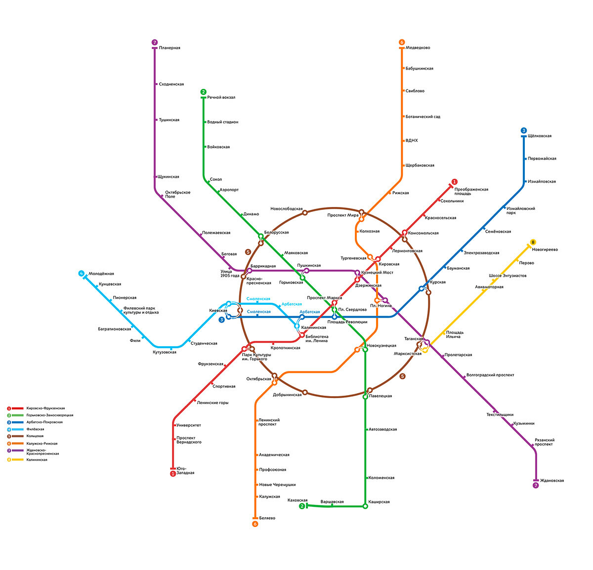
From 1983 onwards, a completely new line was in the process of being built in stages from the south – the gray Serpukhovskaya Line. Many other lines were extended by a few stations each.
An important development was the renaming of many stations. A large number of Soviet names were changed to new ones reflecting historical places and figures. For instance, Kolkhoznaya station became Sukharevskaya; Dzerzhinskaya became Lubyanka; Prospekt Marksa became Okhotny Ryad; and Kirovskaya station was renamed Chistye Prudy.
Zhdanovskaya station was renamed Vykhino, and, in turn, the entirety of the purple Zhdanovsko-Krasnopresnenskaya Line became the Tagansko-Krasnopresnenskaya Line. The Gorkovsko-Zamoskvoretskaya Line became simply the Zamoskvoretskaya Line.
In the 1990s, the Metro evolved very slowly, and the only major development was the completion of part of a new line – the Lyublinskaya Line from Maryino district to Kursky railway station made its appearance in lime green on the Metro map.
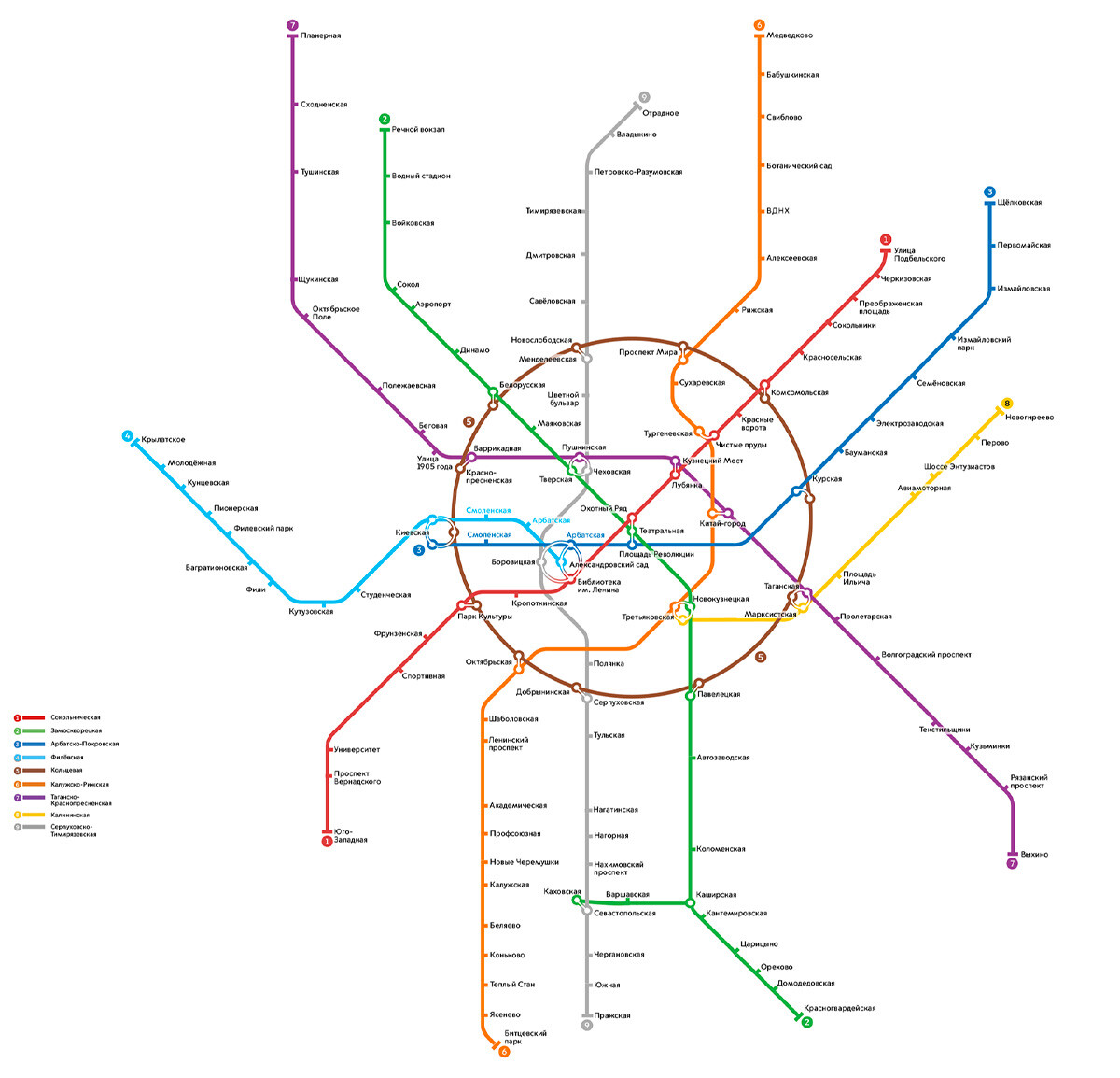
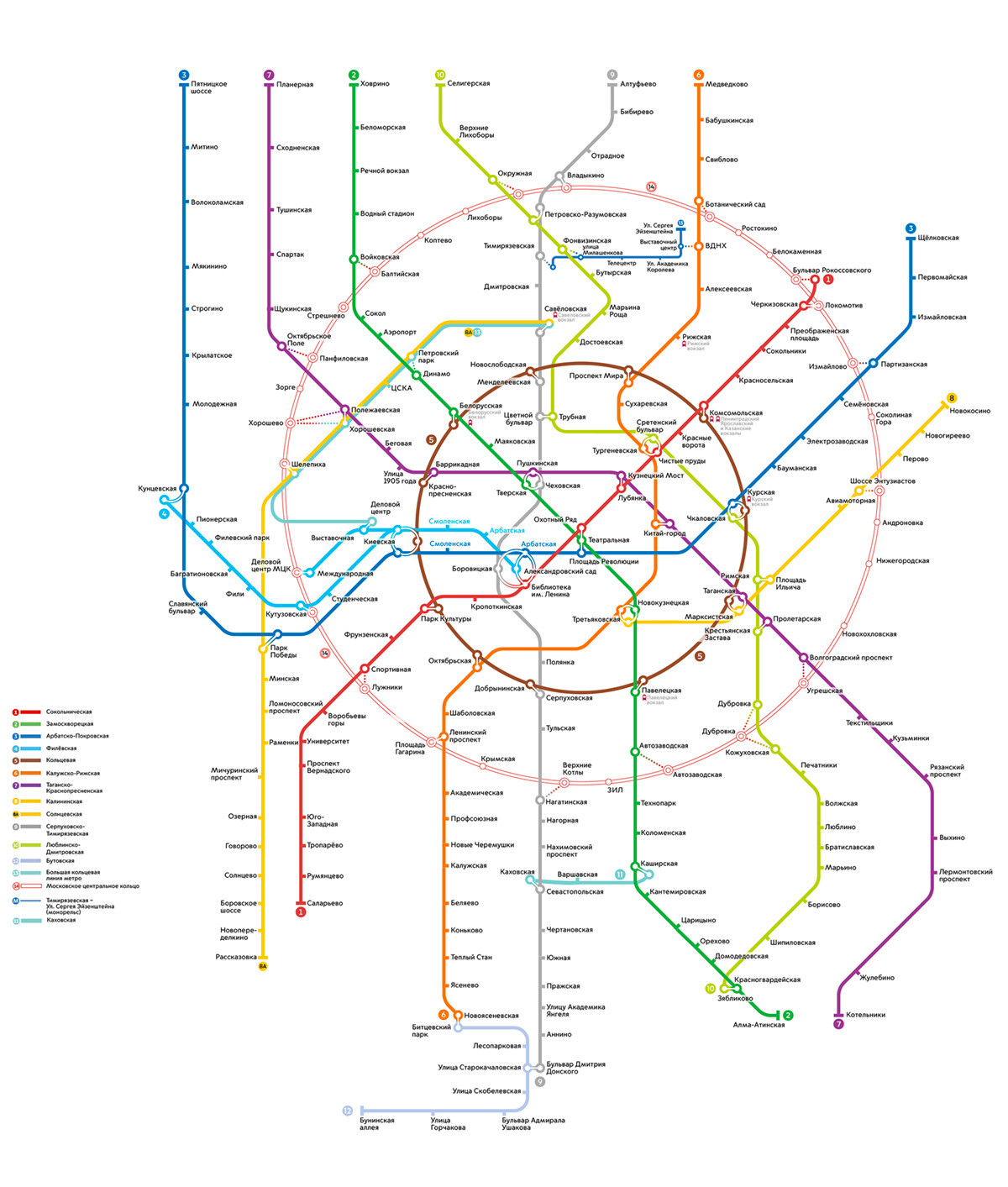
In the 2000s, the Metro started developing more dynamically after the relative lull of the 1990s. Vorobyovy Gory station (previously Leninskiye Gory) opened in 2001 following an almost 20-year reconstruction project.
The lime green Lyublinskaya Line (now Lyublinsko-Dmitrovskaya) was extended, and the blue Arbatsko-Pokrovskaya Line, which for a long time had been just an appendix, was also fully extended to the city outskirts in the northwest.
In 2005-2006, two metro stations appeared to serve the new Moscow City business district: Delovoy Tsentr and Mezhdunarodnaya stations were built on an offshoot of the Filyovskaya Line.
Two small and completely new lines with no direct link to the center were also built: the Moscow Monorail situated north of the Bolshaya Koltsevaya Line (today it runs in "excursion mode"), and in the south the Butovskaya overground "light" Metro line.
In the 2010s, it became difficult to keep up with the rapid pace of metro construction. In 2016, the Moscow Central Circle (Russian abbreviation "MTsK") was added to the Metro map – an overground railway first conceived during Stalin’s reign, but which was only completed in recent times.
New stations and lines were now opened in batches on the Metro network itself:
Another line of the Metro itself, colored pink, sprang up in the southeast, originating from Nekrasovka station in the suburbs.
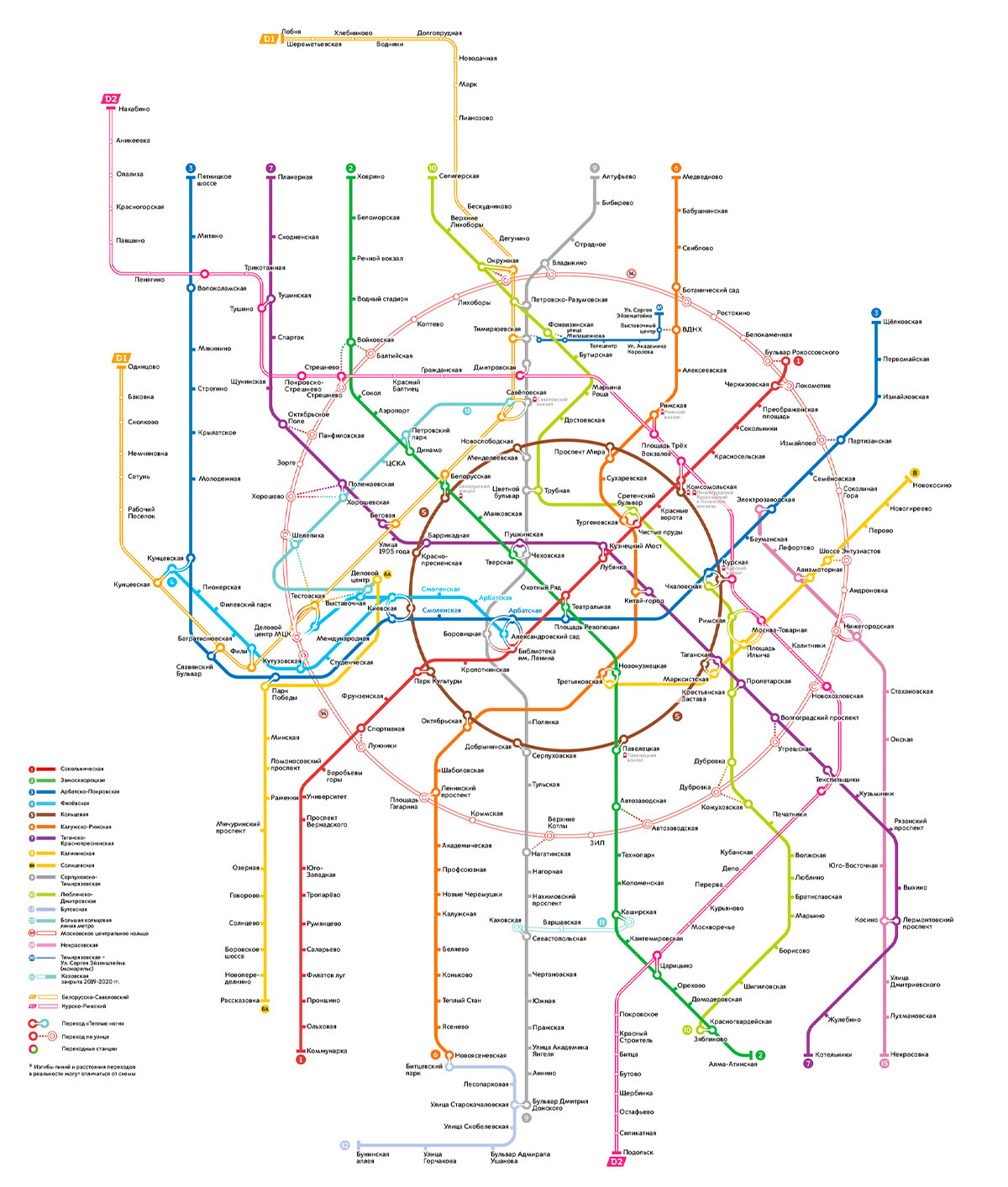
Towards 2019, the so-called Moscow Central Diameters (Russian abbreviation: MTsD) appeared on the map of the Moscow Metro. The two long D1 and D2 lines, based on former suburban railway routes, now linked not just the city outskirts, but also the suburbs, with the center and with one another. They provide a direct route to Sheremetyevo Airport, for instance. Fifty-two and 80 km in length, respectively, they have significantly relieved the Metro's passenger traffic.
Construction of the Bolshaya Koltsevaya Line was completed in 2023, and now there is another way of getting from one line to another without having to travel into the center to use the old Koltsevaya Line.
In addition, another two suburban train diameter lines (MTsD), each 80 km in length, have been added to link the north, west and east of Moscow and of the Moscow Region.
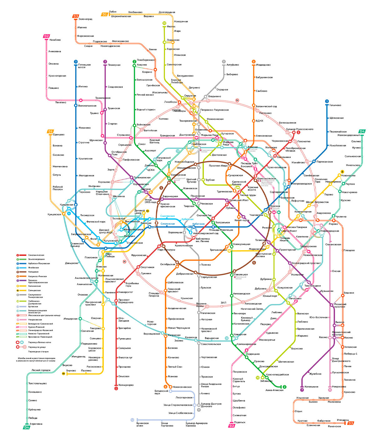
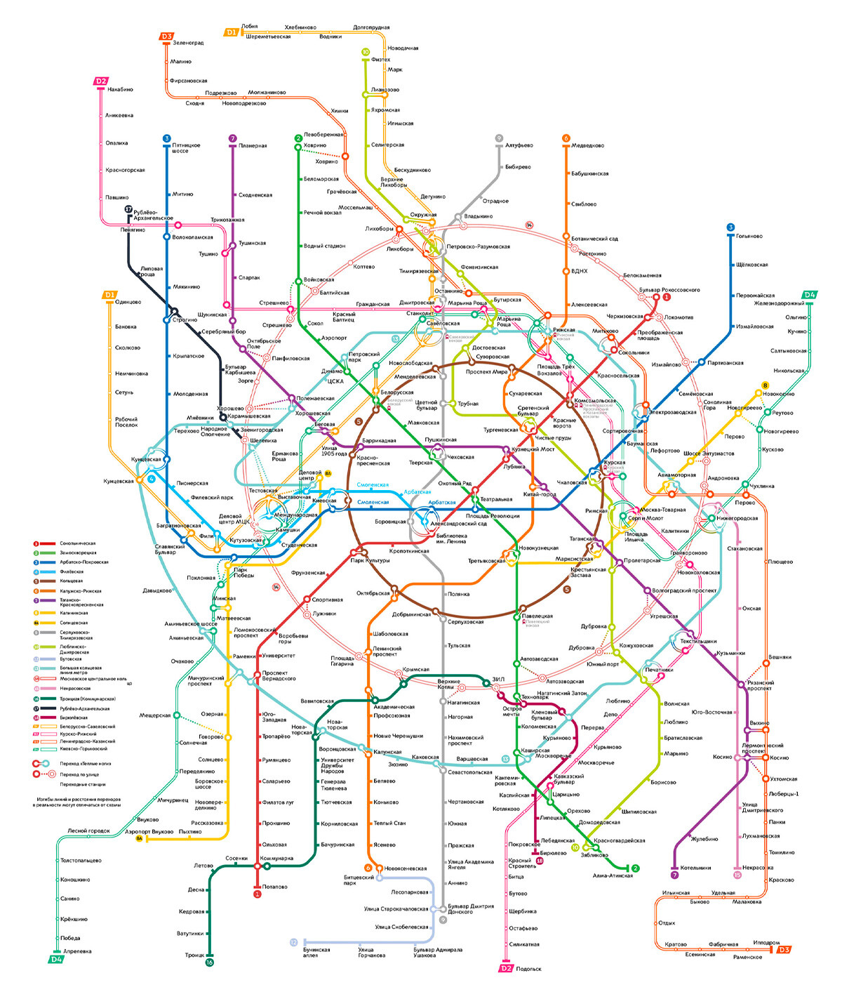
Today, the map of the Metro sometimes looks complicated even to Muscovites. To help out, we have drawn up a detailed guide that should help you understand better.
The transportation authorities have announced a plan for the development of the Moscow Metro through 2027. It provides for the construction of several more lines to connect both the suburbs and areas that have hitherto had difficult access to the Moscow Metro. We can't wait.
Dear readers,
Our website and social media accounts are under threat of being restricted or banned, due to the current circumstances. So, to keep up with our latest content, simply do the following:
If using any of Russia Beyond's content, partly or in full, always provide an active hyperlink to the original material.
Subscribe
to our newsletter!
Get the week's best stories straight to your inbox